Churchtown South and Ballycatoo
Ballintemple-Area Place References in East Cork
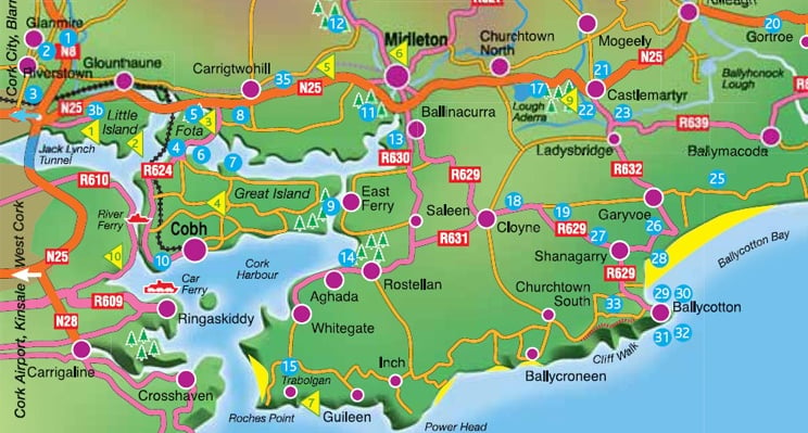
Churchtown South and Ballycatoo are important local reference points in the wider East Cork family landscape. These places help connect the Dorgan / Dargan research to the Ballintemple area, Carrigkilter, Ballybraher, nearby farms, roads, parish records, valuation records, maps, photographs, and neighboring families.
This page gathers Churchtown South and Ballycatoo evidence in one place so these locations can be compared with Carrigkilter, Cloyne, Ballycotton, Garryvoe, Ballymacoda, Ladysbridge, and other nearby East Cork places.
The goal is to preserve local place evidence carefully. Some connections may be confirmed by records, while others remain research leads based on geography, repeated surnames, neighboring families, land records, sponsors, witnesses, maps, and family memory.

Why Churchtown South Matters
Churchtown South matters because it helps place the Dorgan / Dargan research within the wider Ballintemple-area landscape. Townlands, villages, roads, farms, churches, and neighboring places often explain why families appear together in parish registers, valuation records, census returns, maps, photographs, and local memory.
For the Dorgan archive, Churchtown South is useful as a nearby place reference when comparing Carrigkilter, Ballybraher, Ballycatoo, Cloyne, Ballycotton, Garryvoe, Ballymacoda, Ladysbridge, and related East Cork locations.
Churchtown South should be used as a local-place reference point rather than as a final family conclusion. Records connected to this area may help identify nearby families, roads, parish boundaries, map evidence, photographs, landholding patterns, and possible movements between neighboring East Cork communities.
As more evidence is added, Churchtown South can help organize records involving Ballintemple-area place names, neighboring families, and possible connections to Carrigkilter and Ballybraher.
Churchtown South in the Archive
Why Ballycatoo Matters
Ballycatoo matters because it is part of the Ballintemple-area geography surrounding Carrigkilter and nearby East Cork places. It helps explain the local setting in which families, farms, roads, parish references, valuation records, and neighboring townlands may connect.
For the Dorgan archive, Ballycatoo is useful as a companion place to Churchtown South, Carrigkilter, Ballybraher, Cloyne, and other nearby locations. It may help clarify local movement, neighboring families, and repeated place references found across records and maps.
Churchtown South and Ballycatoo help place the Dorgan / Dargan research within the wider Ballintemple-area landscape. This area is important because local family history often depends on nearby townlands, parish boundaries, farms, roads, churches, graveyards, schools, and neighboring households.
For the Carrigkilter study, Ballintemple-area references may help explain how nearby places relate to one another geographically. Churchtown South and Ballycatoo should be compared with Carrigkilter, Ballybraher, Cloyne, Ballycotton, Garryvoe, Ballymacoda, Ladysbridge, and other East Cork places.
These connections do not prove family relationships by themselves, but they help create the local map needed to compare records carefully. Repeated surnames, sponsors, witnesses, neighbors, landholders, and map references may become more meaningful when studied within this wider place network.
Ballycatoo in the Archive
Churchtown South and Ballycatoo should be understood within the wider Ballintemple-area landscape connected to Carrigkilter, Ballybraher, Cloyne, and nearby East Cork townlands.
This area matters because townland names, parish boundaries, road routes, farms, and neighboring families often overlap in family research. A person may be associated with one place in a family note, another place in a parish register, and another nearby place in a land or valuation record.
For the Dorgan / Dargan archive, the Ballintemple-area context helps explain why Carrigkilter should be studied together with nearby places rather than in isolation. Churchtown South and Ballycatoo may help clarify local geography, neighboring family networks, map references, and possible connections between records.
Ballintemple-Area Connections
Related Churchtown South and Ballycatoo Records
These records help connect the Churchtown South and Ballycatoo area to the wider Ballintemple parish landscape around Carrigkilter and Ballybraher.
1836 Edmond Dargan / Dorgan and Mary Cusack Marriage
This Cloyne / Churchtown South parish-register marriage record helps document an early Dargan / Dorgan family connection in the Churchtown South, Cloyne, and Kilmacahill area. Edmond Dargan / Dorgan should be treated as a possible related East Cork branch, not as Patrick Dargan / Dorgan’s proven father.
1842 Elizabeth Dargan / Dorgan Baptism
This baptism record helps place Patrick Dargan / Dorgan and Johanna Flynn’s family in the Carrigkilter / Ballybraher area. It is useful because Johanna appears under the name Nancy, showing how the same person may appear under different first-name forms in parish records.
1847 Patrick Dargan / Dorgan Land Assessment
This Valuation Office Book record provides early land evidence for Patrick Dargan / Dorgan in Carrigkilter before the printed Griffith’s Valuation.
These records should be read together with Carrigkilter, Ballybraher, Cloyne, parish-register evidence, valuation records, maps, and nearby family names.
How Churchtown South and Ballycatoo Connect to the Dorgan Archive
Churchtown South and Ballycatoo help explain the local setting around Carrigkilter, Ballybraher, Cloyne, and Kilmacahill. They are useful because family history evidence often depends on nearby places, not just one townland by itself.
In the Dorgan archive, these places should be used to compare parish-register entries, land records, valuation evidence, maps, neighboring surnames, sponsors, witnesses, and local family memory. They may help explain why the same surnames appear near one another across different records and why families moved between nearby townlands, parishes, farms, roads, churches, and graveyards.
For now, Churchtown South and Ballycatoo should be read as supporting place evidence for the wider East Cork research network. They help frame the Ballintemple-area context, but they should not be treated as proof of family relationships unless supported by specific records.
Related Pages
Churchtown South and Ballycatoo should be read alongside the other East Cork place pages in the archive.
Carrigkilter — the main townland research hub for Patrick Dargan / Dorgan, land evidence, map evidence, parish-register clues, and neighboring families.
Ballybraher — a nearby place-context page that helps explain the local geography around Carrigkilter and the Ballintemple-area landscape.
Cloyne — an important parish and market-town reference point for Dorgan / Dargan and related East Cork records.
Kilmacahill — a nearby Cloyne-area place connected to possible Dargan / Dorgan branch research.
East Cork Places Guide — the main guide to the townlands, parishes, villages, and local reference points used throughout the archive.